TRIP SNIP: Hapuakohe-Pukeitionga, Sunday 16 May 2021
Fourteen WOPpers undertook the journey south of Auckland to tramp in the southern section of Hapuakohe Walkway. The weather was perfect for our out-of-towner: clear blue sky, little wind & surprisingly quite warm. This section is a new walk for WOPs. We did part of the northern section in 2019 but this walk in my humble opinion is even better. The 24.8km Hapuakohe Walkway runs on a north-south axis from North Road near Mangatarata to Mangapiko Valley Road near Waiterimu & is bisected by Ohinewai Road (see map pic). We are to do part of the southern section starting at the end of Mangapiko Valley Road.
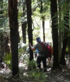
We started off on a farm track & a little way along serenaded by the sound of the Mangapiko Valley Stream like a babbling brook in places! Initially winding your way along the farm track gives you a good appreciation of the valley before heading into the Scenic Reserve. I could wax lyrical on the stunning scenery & foliage etc but the pics hopefully will give you some appreciation & capture the essence of the place. The bush is pristine, peaceful, true tramping tracks just following orange markers, even a bit of bush bashing. Just great - no board walks, bench steps etc, quite untouched. Luxuriant green foliage. The canopy punga, tawa, kohekohe, pigeonwood, we thought we saw totara. Very damp in places where little sun & perfect for fungi. We saw many varying types, orange/blood red toadstools, puff balls & other unusual ones (see pics). Also what looked like rata flower; I guess it is a member of the Metrosideros family. I looked it up, looks like Metrosideros fulgens forest liana or vine endemic to NZ. Seems there are many vareties!
The track muddy in parts but nice & soft, easy on the body in that respect but plenty of uphills & down so poles very useful to negotiate our way. Sadly not a lot of birdlife & saw no traps. Heard kereru wooshing their way thru, lower down tuis & fantails & up high on the hills saw welcome swallows. The track often opens out into wee clearings where we can view the rugged hills. After a slog up a ridge, with a break partway up for morning tea we emerge at a farm fenceline (see pics) with broad views of hills & farmland & cattle & sheep rather curious at this gaggle of women staring across at them. The track runs up a reasonably steep hill following the fenceline then plunges into the bush again. From here the track twists & turns up & down on Pukeitionga ridge & then out onto private land Pukeitionga Station (510m). Very extensive views & the day was perfect to appreciate it. We headed up another steep hill to the Telecommunications Tower (see panoramic pic). There is a special accessway for the public thru the private land as the track continues on till you reach the northern end of Hapuakohe walkway. We lunched by the smaller cell tower & were bombed by giant ladybugs who were crawling all over the tower & sometimes on us!
After lunch at 1pm it was time to retrace our journey back to the cars. So more of down, down & careful picking our way on the steeper bits. No mishaps just the odd skid but that is all. So just on 3pm we were back at the cars parked in the paddock, stopping on the way again to enjoy views, different foliage etc. Estimated distance covered for the day approx 12kms.
A huge thank you to Elizabeth for checking out this walk for us. Highly recommended. Thanks to everyone for your company today.
Colleen W.
For photos from Colleen, click here